Decolonizing the Settler City
This year witnessed the timely launch, against the backdrop of dramatic anti-racism insurgencies, of a new journal: the Journal of Race, Ethnicity, and the City (JREC). The journal’s editors rightly identify race and ethnicity as concepts that are fundamental to understanding cities today. JREC is dedicated to exploring the complex relationships between race, ethnicity, and other identities as they are materially expressed in urban space. The journal aims to fully confront the “ugly realities” of discrimination, civil rights violations, and unequal access to opportunity in cities at home and abroad.
Highlighting JREC’s inaugural issue is a very important review article by Janice Barry and Julian Agyeman about urban planning and placemaking in “settler-colonial” cities of the United States. Settler-colonial cities are those in which native or indigenous populations have been displaced, dispossessed, and effectively disappeared from processes of urban development. Colonialist (i.e., Eurocentric, monocultural) planning and design paradigms have rendered indigenous peoples invisible except where their histories are marked by street names, public art and imagery, and performances such as Indian markets and powwows. In other words, natives are typically reduced to subjects of display or “spectacle,” often packaged for consumption by settler society. Barry and Agyeman argue that modern planners have been more focused on what cities can become than on who belongs in them. They usefully synthesize literature calling for the meaningful involvement of native peoples in “co-producing” the city. They urge “deepening the pot” of planning ideas that can make cities more equitable and inclusive. Most importantly, they highlight the critical need for urban spaces and places that facilitate expression of indigenous knowledges, practices, and relationships.
One particular observation by Barry and Agyeman provides the departure point for this essay. That observation is the frequent association, in both scholarly and popular consciousness, of native peoples with natural landscapes. Critical scholarship has served notice on the theories and policies that associate “authentic” indigeneity with rural and remote places: the wilderness, the bush, the outback (e.g., see here). Land acknowledgements have become standard fare among American academics as a show of respect to the native people who occupied territory long before colonial institutions took over. The problem is that this frequent association of native people with natural landscapes ignores the fact that precolonial cultures of the Americas produced complex cultural landscapes, including ones that can be properly described as urban. By ignoring such complex settlement infrastructures and histories we preclude learning from ancient cities about how modern cities might be designed and built to better support indigenous belonging. The rest of this essay explores this topic using a case study from ancient North America. My goal is not to speak for indigenous people or even suggest how indigenous placemaking is to be accomplished. Instead, my goal is to deepen the pot of ideas for disrupting colonialist planning and design, and provide grist for imagining more equitable and inclusive urban futures.
Indigenous Urbanism at Cahokia
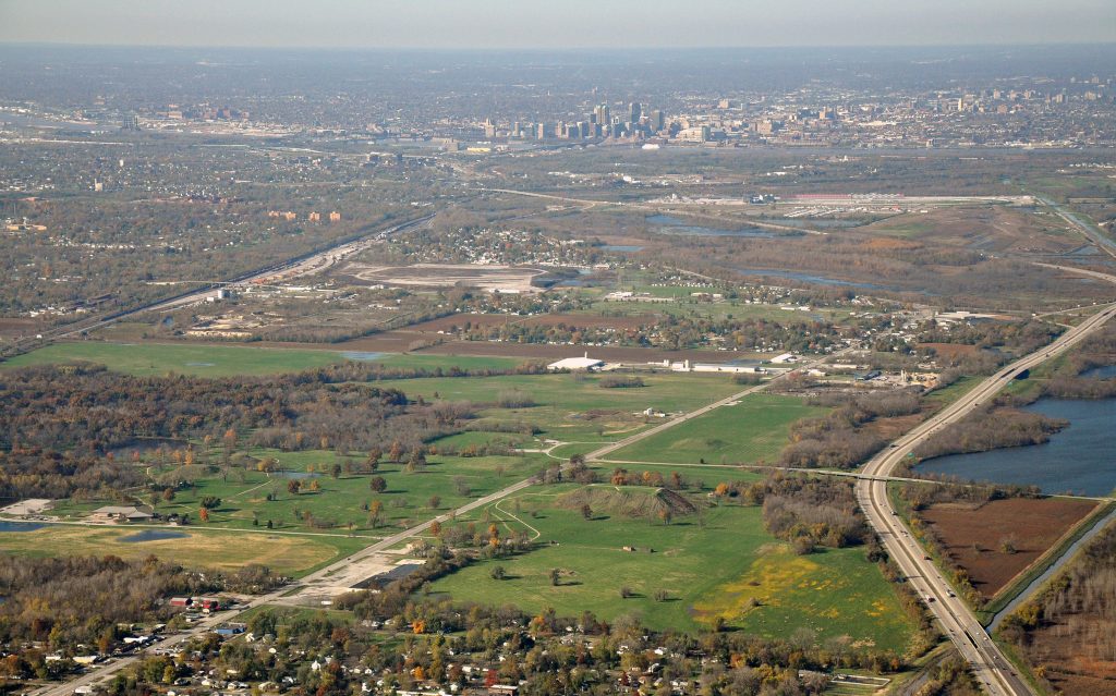
The native societies of precolonial North America are generally considered to fall outside the scope of state-level, urban civilization. The continent is known primarily for its record of relatively small-scale hunting, gathering, and farming societies that actively resisted “civilizing” impulses in the technical sense of that term. However, North America has several good examples of novel urban and near-urban settlement forms that were powerful in their reach and influence. The most significant of these was Cahokia, a vast Mississippian metropolis that rose to prominence in the central Midwest between 1000 and 1200 CE. Because of settler-colonial agriculture, road building, and other activities Cahokia today is a shadow of its former self, contained within a State Historic Park in East St. Louis, Illinois. The residents of Cahokia are ancestral to Eastern Woodlands Indian groups that the Spanish encountered at contact. Good evidence from studies of artifacts and human biology indicates that Cahokia was a multi-ethnic, intercultural polity. In other words, Cahokia was a city of immigrants—perhaps America’s first.
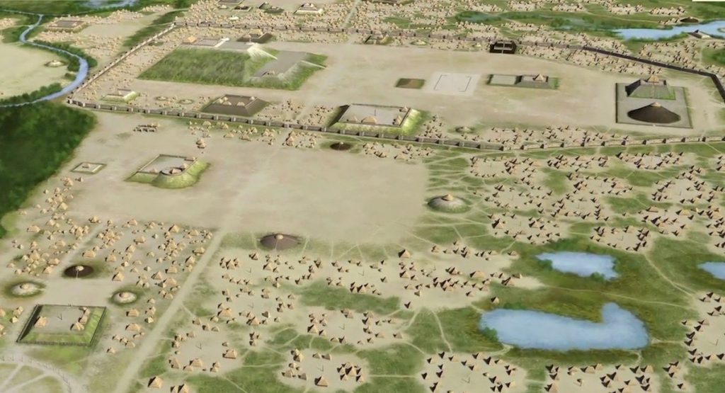
The builders of Cahokia successfully harnessed ethnic, linguistic, and other cultural diversities to make a dramatic and unprecedented investment in place. The city sits in an environment of very rich agricultural potential known as the American Bottom. It had access to many communication and trade corridors defined by interior rivers and streams. This central location was undoubtedly part of Cahokia’s appeal. The Cahokian metropolis covered at least 20 square kilometers. It contained large earthen mounds in a variety of forms (conical, linear, platform) and clearly differentiated public space, residential space, and suburbs. It incorporated outlying shrine complexes, monumental acropolises, and farming villages. The city housed up to 20,000 people. In its heyday, Cahokia was comparable in size to its contemporaries of London and Paris. At its height in 1100 CE, tens of thousands of additional people identified with Cahokia over an area of at least 2,000 square kilometers.
The monumental earthen mounds at Cahokia were arranged in coherent spatial patterns. The city was planned using principles of cardinality and oriented to the movement of the sun, moon, and perhaps other heavenly bodies. Public monuments and plazas were connected by avenues and causeways, which also linked the downtown core to suburbs and exurbs. Natural features such as hills, springs, caves, and sinkholes were hard-wired into the Cahokian urban plan. In at least one instance, public monuments and their connecting causeway were built in the swampiest part of the city. This materialized a human connection to Mississippian cosmology’s watery realm of the dead, and indicates that Cahokia’s cityscape was both a practical and theatrical exercise. Herein lay another big part of the city’s appeal. Cahokia’s urban plan encoded mythic narratives about ancestral origins and the relationship of people to the cosmos. Associated socio-religious and cosmological ceremonies and processions, along with lively markets and athletic competitions, produced a vibrant civic life. Monuments and designed landscapes may have given residents and visitors precisely the sort of “embodied” experiences that contemporary critics of architectural practice impressed by developments in cognitive neuroscience (e.g., Sarah Williams Goldhagen) suggest are sorely needed in today’s cities. The Cahokian built environment tapped into human nature and evolutionary memory. And, it almost certainly created something of a shared civic identity out of Cahokia’s many diversities.
Several different models theorize how Cahokia was planned and governed. In some models, Cahokia was a politically-centralized state run by autocratic leaders who used a combination of ideology and political force (or at least the threat of force) to maintain social order. In other models, Cahokia was a communal undertaking based on shared “Big Ideas” and forms of political power that were rather more fluid and non-hierarchical. The precise content of these integrative Big Ideas is tough to determine archaeologically. However, it’s a good bet that they were rooted in animism and “world renewal” rituals, and communicated through material patterns whose meanings for citizens were deeply internalized and taken-for-granted.
My own inclination runs toward the collective and communal. I see Cahokia as less a distinct polity than a “plurality” or “hybridity” in which social difference was accommodated rather than subjected to strict regulation and control. In other words, Cahokia’s governing sense of community reflected a “being in common” rather than a “common being.” Archaeologists are discovering that even the biggest precolonial cities of the Americas were collectively governed. One line of evidence for this view is that Cahokia’s growth doesn’t follow scientific laws of urban scaling discussed in a previous essay. In other words, it lacks the regional bureaucratic organization that would be typical of an urban formation of its size and spatial extent (for a full report, see here). This, and other lines of evidence, suggest that the Cahokian cultural order was cosmopolitan, open, and permeable. Indeed, in many ways Cahokia echoes the cosmopolitan brand of urbanism discussed here. At the same time, I’m not naïve about the economic inequality that existed at Cahokia. A comparative study of Gini Coefficients generated for a sample of ancient cities discloses that Cahokia’s value of .57 is comparable to that of its modern sister city, St. Louis. However, economic inequality at Cahokia may have been experienced very differently than how we moderns experience it.
The Past Serving the Future?
The current challenge to Cahokian archaeology is discovering the organizational principles and commitments that promoted a social “being in common” and its associated forms of spatial belonging. What were the norms of ethnic co-residence at Cahokia? How were they established, both institutionally and materially through urban planning? How did these norms produce what Xavier de Souza Briggs, in a study of medieval Cordoba (a European city that flourished around the time that Cahokia was rising), describes as the “cross-cutting loyalties” that bridge ethnic difference, promote collective action, and defuse social conflict? And perhaps most importantly given the aims of the JREC and Barry and Agyeman’s useful provocation, what planning insights or lessons from Cahokia and other indigenous cities can be “scaled up” and applied in placemaking practices today?
That last question is a tough one and attempting an answer would take me out of my comfort zone. But it seems that any planning intervention or disruption aimed at decolonizing the settler city must be informed not only by new theories and methods of co-production, but also by settlement ontologies that are more thoroughly relational in character. The ancients saw their cities as fully articulated forms that intimately connected natural features, celestial bodies, architecture, open spaces, people, material substances, cosmologies, histories, and memories, with each element of the whole having particular affective qualities and powers. This vision is very different from the one informing settler-colonial approaches to urban planning and architectural design. There is a rich body of empirical evidence from the ancient world documenting the differences. Exploring these differences and strategies for enacting them would promote a stronger linkage between the city of becoming and the city of belonging, as recommended by our best scholarly critics of the contemporary urban condition.
Acknowledgement: My discussion of Cahokia in this essay is indebted to the work of my colleagues Susan Alt and Tim Pauketat, co-editors of New Materialisms Ancient Urbanisms, Routledge, 2020.
Leave a Reply